Monday 28 July 2014

Fiset Brook Falls

Today I went through the series of waterfalls along the Fiset Brook. To get to the bigger waterfalls, some people wait until they are above the falls and then descend--the geocache listed below is one entry where you will find the directions "Follow this trail until your GPS points directly into the gorge and begin making your way down to the bottom." However, there are smaller waterfalls and beautiful pools to be found along the way if you join Fiset Brook immediately after leaving Le Platin Road. I'd recommend parking at the end of Le Platin Road (off the back road of Cheticamp), going on foot up the hill, turning down the ATV trail on the right, and hopping down to the brook near a small pull-off area (My apologies--did not have my GPS on this fine day to mark coordinates). HOWEVER---there will be two options available to you at some points along this follow-the-brook journey. One: climb, two: shoulder-deep swimming. Today, I climbed whenever possible--had not brought proper swimming gear, had my iphone to protect--but I still wound up putting my phone in a ziploc bag in my friend's backpack and jumping into a couple of pools when I felt the swim was a much safer bet than the climb up a cliff-side. This was my first time navigating the brook from the "bottom up" and I underestimated the depth of some of those pools. It's a huge regret to me right now, as I lack any pictures of the biggest falls. (Depending on your generosity towards use of the word "falls," you may count five of them before you get to the tallest.)

Also, it may be noted, I'm eighteen weeks pregnant and erring on the side of caution more than usual. A stronger climber might make it from the lowest falls to the highest without swimming if following the brook, but it's doubtful--and would not have happened today. One of my companions got a couple of good knocks to her elbows when she fell from the rocks around one of the deeper pools on the way back down, hitting her arms first and then crashing into a pool that was just deep enough for her to submerge herself completely while saving the backpack with completely outstretched arms.

At the last couple of stages of waterfalls, there are ropes to guide a person up and above these bigger sets.

Fiset Brook


The first pool--this was easy to climb around.

The first falls


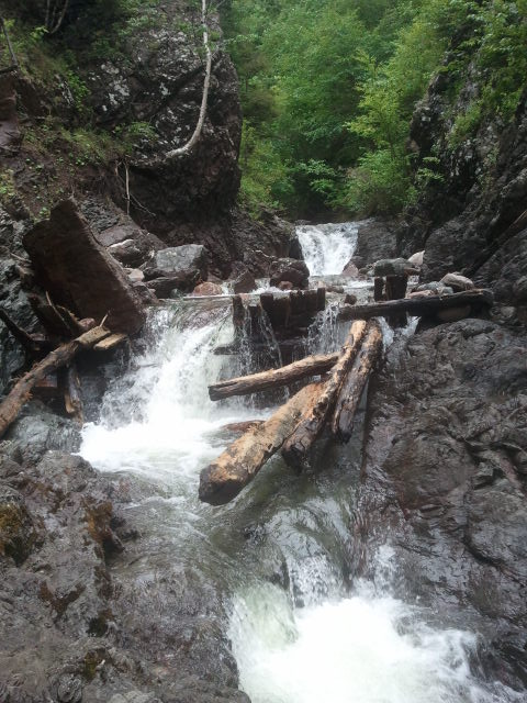
The fifth falls (?)--depending on how you count!


Geocaches in Area:
"Fiset Brook Falls" N 46 35.930 W 060 58.290 Status: Good (2014-06-14) GC36NT3

Friday 25 July 2014

Franey

The Franey trail is one of the most rewarding hikes in the Cape Breton Highlands National Park. Near Ingonish, the trail-head can be found north of the Clyburn River. There is a fire access road that permits driving for close to a kilometer to a parking lot. The hike itself is a loop of about 7.4 km that runs from 310 to 1,410 ft., taking between 2 and 3 hours to complete.


Map - Franey
Map - Franey © Parks Canada
Franey is a challenging hike, but the trip is worth it--it's one of the best hikes on the Ingonish side of Cape Breton Highlands National Park. Along the way, look out for wildlife in the Acadian forest. Moose droppings are plentiful, and the majestic animals are often close. After progressing up and out through this hardwood forest, often on stairs and though a steep, narrow track, you'll enter the boreal plateau and begin leveling out. Shortly thereafter lies a look-off with views of the Ingonish Harbor and Cape Smokey, but a short distance away, at the very top, lies the true reward. Take a seat on one of the large, flat rocks and bask in panoramic views of the coastline from Cape Smokey to Ingonish and of the Clyburn River canyon far below.


Thursday 24 July 2014

Egypt Falls


I neglected to write about Egypt Falls for a long time, if only because I've been there often.  Still, it's a must-see spot that both Margareers and Scotsvillers claim as their own. The trailhead can be found off Piper's Glen Road in Upper Margaree. On my last visit, the sign had been knocked down and was laying on its front, but a few scraps of flagging tape still marked the spot.

The hike is only about 250 meters, going down on the way in. I've always been a bit miffed by trails that offer the reward before the climb (as if they could change!). So, prepare for an easier way in than out, and wear decent shoes for both the hike and navigating the brook rocks at the base. Near the bottom, ropes can be found to help you down the steeper section with caution. The wide falls have a strong flow and I've always seen deep enough pools to take a dip if you're so inclined. My usual routine is to forget to wear bug repellent and spend only minimal time enjoying the beauty of the falls, but those who come prepared (or come on a breezy day) might enjoy a picnic or a longer stay. This is a densely forested area, and the flies are often out in full force.

A brief visit to Patterson's General Store after my last hike to Egypt Falls led to a conversation with an older gentleman about the spot. He hadn't been there in several years (poor knees) but was kind enough to give me a brief history lesson on the name of the falls--specifically, that "his" people would never call it Egypt Falls. It's been Piper's Glen Falls since he was young, and, alternatively, Appin Falls before that--named after the Steward family from Appin, Scotland, who lived near the falls sometime in the 1800s.

Geocaches in area: 
"A Piper's Watery Delight" N 46° 11.600 W 061° 07.737 Status: Unknown, not listed on 2014-07-24

Freshwater Lake Lookoff

The freshwater lake look-off trail is a perfect little hike for someone short on time. We hit this one up on the way back from a soccer game in Ingonish. It only takes about ten minutes of walking, but you do climb from 35 to 150 feet in elevation in that short span. The trail is less than 1/2 kilometer return.

The trail is one of the first trail-heads you'll see from the Ingonish side of the Cape Breton Highlands National Park--across from the park's Administration Building in Ingonish, and well marked.


Map - Freshwater Lake Look-off
Map - Freshwater Lake Look-off © Parks Canada
Though steep, most of the hike features wooden steps and footing can be maintained somewhat easily. At the top, you'll be rewarded with a viewing point of Ingonish Beach, Freshwater Lake, Middle Head and Cape Smokey.


Southeast view, with the park's administration building down below.


A couple of shots on the way down--easier to take than going up!


Fielding Road to Wreck Cove Hydro Station

Warning: this post has an overload of pictures. I take many more on a driving trip than a walking trip. Asides from the added logistical difficulty of snapping while walking, I suppose that when I hike, I'm often all wrapped up in the sometimes meditative (sometimes tiring) aspects of the journey it takes to get to a destination. A long drive is very different. Here is a panoramic shot taken from Wreck Cove, looking out to Bird Islands. 
A few weeks ago, I mentioned to Russell that I hadn't yet been in to see the Wreck Cove Hydro Station. He had been there a couple of times, the most recent being about eight years ago, and so he wanted to check it out as well. To add a bit to the adventure, we decided to drive in from Margaree via the Highland road system (and not the Wreck Cove end), making it an entirely dirt-road trek 


The Wreck Cove station is the only non-private hydroelectric plant in Cape Breton. To get there, we we drove from Fielding Road in Margaree Valley to the end of Highland Road, passing the road to go to Wreck Cove, and having to turn around a couple of times to locate it. Even with a map in hand from the Department of Natural Resources office in Margaree, it gets tricky out there. After selecting the right trail, it was a slower drive the rest of the way, as we moved from the wide Highland Road to something much narrower and maintained only by the Snowmobilers Association of Nova Scotia. Still, my little Civic made it through and the roads improved again once we got closer to Wreck Cove end.


Who can pass up a view from 1200 feet above the water?


Geocaches in area:
"Cabot Trail Tour series (No.3) Wreck cove" N 46° 31.867 W 060° 25.051 Status: Good (2013-08-29) GCNM6M
"Wreck cove Hydro project ( Surge Lake)" N 46° 32.245 W 060° 26.494 Status: Good (2013-08-29) GCW1HP
"Wreck cove hydro project (The windmill)" N 46° 32.913 W 060° 29.721 Status: Good (2013-08-29) GCW1GQ


Tuesday 13 August 2013

Aucoin Brook Falls


The ATV paths that run behind the town of Cheticamp grant somewhat easy access to a number of beautiful waterfalls. The plan for today was to do some of the ones that can be reached up LePlatin road, and though we only managed to get one in before we ran out of time, the day was not a disappointment.

LePlatin road can be found off the Cheticamp Back Road. From the Cabot Trail heading north toward Cheticamp, take the soft right at Flora's gift shop and take another right at LePlatin and park near the end. On foot, continue up the road and down the middle trail. We only had to cross the brook once to find the falls.

Some old building foundations can be found along the brook, and pieces of an old wooden dam remain at the top of the falls. If climbing them, keep your eyes open and don't trip on the metal ties in the rocks from when the dam was in use.


 Geocache in area:
"Aucoin Brook Falls" N 46° 36.306 W 060° 58.646 Status: Unknown (2013-08-11) GC36R4K

Magic Cove / Sight Point

It was only in my earlier twenties that I became much more interested in hiking in the areas up Route 19 (Inverness, Mabou, and such). By this time, I felt like I had done everything in the National Park ten times over and it was time to start moving south. By this time, the problem with Mabou was the spruce bark beetle, which devastated the woods along many of these trails, closing popular spots like Beinn Bhiorach, among others. Now that these trails are reopened, I'd like to spend more time up there. 


It you're interested in doing a few treks, a map of the Cape Mabou hiking trails system can be purchased at the Information Bureau in town and a few other places (the Bear Paw gift shop is one) for five dollars in the 2013 season. It was a toonie the last time I got one, but I wanted another in case anything had changed since the closings and reopenings of the trails that I needed to know about. I wanted to keep to the shore, so I did the MacKinnon's Brook trail today. I wasn't disappointed with all the cool spots I found, especially Magic Cove, which I had heard of being used for a picnic spot but had never seen.

So, we started from the Sight Point end by car. That is, at the southern end of the town of Inverness, turn left at the Tommy Cat Bistro and start climbing. Drive up a few kilometers to where the pave turns to gravel. HERE you may want to consider your driving strategy. Brave and with 4-wheel drive? No problem. Not so brave and driving your Civic? Meh. I wasn't worried about my car clearing the road itself. The problem is that the road eventually becomes a one-laner, and you just have to hope that any rigs meeting you will be able to take the ditch if your car can't. We met four vehicles, and Russell was driving. He had the courage to pull a lot closer to the sheer drop-off edge than I would have, and the vehicles we meet took the ditch with ease.


Magic Cove is a short detour from the MacKinnon's Brook Trail using the co-ords from the last geocache listed here. It's a very cool spot and not one to be missed.

Geocaches in area:
"Up the Sight Point Look-Off (#1 of Series)" N 46° 12.345 W 061° 21.523 Status: Good (2013-08-11) GCQDZJ
"CMHHT - MacKinnon's Brook Trail" N 46° 10.697 W 061° 25.678 Status: Unsure (2013-08-11) GC162KG
"Magic Cove 'Do you believe in Magic?'" N 46° 11.549 W 061° 24.732 Status: Wet (2013-08-11) GCXMCV