Thursday, 13 June 2013

Le Chemin du Buttereau

Le chemin du Buttereau is an old trail that connected the community of Le Buttereau to the neighboring village of Chéticamp from the late 1700s until the Cabot Trail opened in the 1930s. At 4.6 kilometres return, it's not an overly long hike and makes a nice walk on a hot day if you wish you spend some time out of direct sunlight. It rises from 25 to 65 m (80 to 215 feet), so it's not the steepest trail, though there's one a small climb in sections. The term "buttereau" actually means small hill, and this slight rise will take you above the Cheticamp River and Gulf of St. Lawrence for some nice views. The trail is self-guilding, winding through mixed Acadian forest and around old foundation ruins. Beginning at its southern end or first entrance, you'll feel at first as though you're heading back towards Cheticamp, only to begin curving to the north right away. 


The remains of old foundations that you pass belonged to the families who lived here, including David à Sambo and Rose Chiasson (and their 10 kids), Georges à Cacoune and Josephine LeBrun (and their 10 kids), Séverin à Édouard and Nélée LeBlanc (and their 10 kids), Joseph à Cacoune and Marie Deveau (and their 11 kids), and Auguste à Édouard and Hélène LeBlanc (and their 9 kids). The names following the husbands are those of their fathers. After a few old remains, you'll notice the covering to an old well to the left.


When you reach an intersection where you can go left or right, you have reached Le Buttereau, the loop part of the trail. It's well worth it to catch the views from these look-offs. During the fishing season, you can see boats out here. An informative panel along the trail tells us that the original inhabitants of Le Buttereau would head to La Bloque or Chéticamp Harbour to meet with the boats, and stay for the week before returning home. At 50 cents for 100 lobsters, they were only eking out a living for themselves.


Though you can loop around Le Buttereau, finishing it til its end will you give you the following views. When you get to the opposite end of the trail, you'll be looking at the Grand Falaise (the Big Cliffs).


The parking area at the Grand Falaise is where you might wish to begin another excursion that I discussed on another day, a waterfall that is very rewarding if you're careful to get there--Righwash Brook Falls.

Shean Trail: Inverness to Kenloch Church

I'm a cigarette smoker who bikes, hikes, and can occasionally train to run up to 5 miles, only to quit when it becomes easier and thus boring. On my good days, I may consider myself to be an enigma. On my bad days, I'm nothing but a shithead. In any case, I like to be outdoors and I'm willing to work hard to get to a beautiful scene (climb mountains to see valleys). But I'm not the type to run for running's sake. Or bike. Or whatever the case may be. So I'm not going to get out my bicycle and start doing the Cabot Trail on the exact same road that can be driven. Sometimes I even think it's horrible that we encourage such an activity on a twisty, cliff-side road with no bike lane. When I hike or bike, it's usually because I'm going someplace that cannot be driven. When I do feel like moderate exercise, I stick to the easier routes. Behold--the Inverness Rail-Trail (officially the "Shean Trail" segment of the Trans-Canada trail).

The Rail-Trail is a multi-use trail built upon the old railway bed that stretches from Inverness right to the Canso Causeway--about 92 kilometers, mostly closely following Route 19, the paved "Ceilidh Trail" highway that leads Margaree Forks to Canso. Its parts have localized names. Today I stuck to the Shean segment, running alongside the town of Inverness, but I've also spent a lot of time in the Mabou Rivers segment and the Ceilidh Coastal segments (I'll save those for another day). Depending on where you begin on the trail, it could be considered quite boring on foot. What makes this my preferred biking trail is that its fantastically flat--more or less from this end of town (Inverness) to the Causeway. Conventional trains did not go up steep inclines because of the traction that would be required against the steel rails.

This particular section of railway was completed in 1901. The story goes that the government paid for the route to stretch right to Chéticamp, but the constructors of the railway were also the owners of the coal mines in Inverness, so they quit once it reach their own desired destination and were never forced to continue. The railway was used for commercial passenger travel, but mostly for coal transport. The company went into receivership in 1929 and the railway became part of the Canadian National Railway until they stopped running the trains here in 1986. After this section of rail was closed, many volunteer groups, including the Judique Flyer Association, the Inverness Trails Federation, the Chestico Trail, and the Ceilidh Coastal Trail Association, as well as different levels of government agencies, made a joint effort to build a multi-use trail on top of the stripped rail bed, making it part of the Trans Canada Trail--the world's longest connection of trails. When completed, it will stretch over 23,0 00 kilometers and connect Canadians from the Atlantic, Pacific, and Arctic Oceans.

You can begin the trail at any number of access points. It begins at the Inverness Railway Station that is now the Inverness Miner's Museum. I rarely park there, since there's an access on the other side of the road and I don't want to be in town long with my dog, who I take with me whenever she and I are both up for it. She listens well enough that I don't feel the need for a leash and can get a good run in there. Most of the trail is a good distance from the road, though there are some places where the trail runs almost alongside, or where it crosses side roads or private properties near which a dog needs to watched carefully. In any case, I usually park near the visitor's center or Gables Motel and walk over to the trail from there. You'll see the signs marking its beginnings. Another good access from Inverness (and quieter if you've got your own pup with you) is to head up the Deepdale Road just after Inverness (toward Lake Ainslie) and park at the access that's right at the Kenloch church on your right side after a few minute's drive. A tip to finding such access points is to look for signs warning of ATV crossings, since 4-wheelers and snowmobiles regularly use these trails. Once on the trail, kilometer markers that run from south to north will be a guide to where you are.

There have been many improvements to the trail made in recent years--drainage is excellent, the bridges and their approaches well-maintained, and so forth. I was happy to have excellent biking in Inverness on this day, for the Mabou Rivers section that I did not so long ago had a fine sand surface placed on it, making a lazy biker like me just a tad bit slowed-down (though it's a pretty section and should not be skipped).


One of my favorite features is the Deepdale Trestle bridge, high above a deep gorge.


The Sean section of trail has many small branch-offs leading uphill from which great views of the Inverness Harbor and Cape Mabou Highlands can be seen. I usually leave my bike at the bottom for these and walk up.

Not part of the trail, but one of many branch-offs above town from which great views can be reached.


 Geocaches in Area: 
"Hurricane Series" (Series) Status: Some good, some bad (2013-06-13) i.e. GC2ET93
"Blueberry Stash"  N 46° 13.435 W 061° 18.477 Status: Missing (2013-06-13) GC2CZFC

Friday, 7 June 2013

Chéticamp Island

Though I'm from the area, I appreciate the value of having a day off and pretending to be a tourist, revisiting old favorite spots and searching for something new and different that wasn't seen before. Today I went for a coffee run to Cheticamp and ended up exploring Cheticamp Island from one end to the other.


Geocaches in Area:
"Cheticamp Island Cemetary" N 46° 36.302 W 061° 03.425 Status: Good (2013-06-07) GC354Y9
"Frenchy's Playground - Welcome Home" N 46° 38.930 W 061° 01.554 Status: Good (2013-06-07) GC1K5X2

Tuesday, 4 June 2013

Bald Mountain

Spontaneous road-trips, followed by little-planned hikes, will one day be the death of my vehicle. I think one of the biggest mistakes I made in my twenties was my decision to buy my Civic. With my bad university credit not yet buried behind me, my payments are outrageous (thanks, subprime!) and the car is just entirely all wrong for me. First of all, I like to take my dog places. This car is a two-door, non-hatchback style--meaning it is all but impossible to save both front and back seats from the wrath of my mutt, Ella. Cover one seat, and she's bound to choose the other to land on. Secondly, my '09 model is about as low as a car should ever be legally allowed to get in Cape Breton. Just in my regular driving alone, which admittedly includes a few bumper scrapes in Sydney, I've managed to tear off a front fender clip, then months later lose the entire fender (fell off because of snow drift, plus said clip), and split my windshield washer tank. While the coupe's fuel economy is admirable, it is not the best road-tripping vehicle for some of the more rural parts of the island.

Thank God for travel companions who think to check the depth of pot-holes. Here is Russell throwing stones on the road ahead.

Today, however, that car made me proud--enough to continually discuss names for her on the route. I'm not naturally a namer of cars. At least, I don't have the passion and discipline required to perfectly name a car, then stick with that name (most of my vehicles have had several names over their lifetimes). This particular route that elicited so much car-love was the trek up Bald Mountain, past the end of Big Baddeck Road in Big Glen. We took Sandy? Gerry? (I've forgotten already) to places she should never have gone--several times in the wrong direction, then too far in the right direction). An online description suggests the trailhead is at N 46° 14.139 W 060° 40.969, with the trail starting to the WEST of this location, but my GPS did not seem to want to keep up with me on this day. In any case, we eventually found ourselves on track.

For the end of April, there was still a great deal of snow in some places, and we found ourselves too far into a classic road-that-turns-into-an-ATV-path to turn around. We continually spoke of our stupidity for not bringing our X-Terra instead, our gas-guzzling 4-wheel drive titan. In any case, we made it past the snow, high water, and washed-out sections of road to make it to McMillan cemetery.


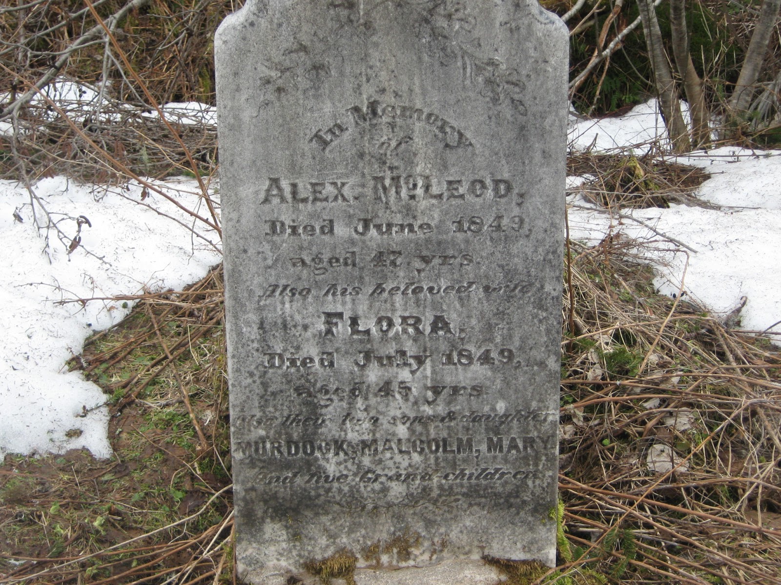
We decided to park here, at this entirely unexpected cemetery. I hadn't read about it when I decided to go to Bald Mountain, but I still had it programmed into my GPS from my last cemetery tour of Baddeck (there are a series of geocaches planted at cemeteries all over Baddeck, and some are way off the beaten path). On that day, we spent a full eight hours or so searching out cemeteries, and never came close to this one, so we left it off the list. I was happy for this chance stumble-upon, and to see some of the older graves at this site in the middle of nowhere.
I wanted to name the car Alex, after the person to whom this headstone belongs, but that's also the name of Russell's boss, so he vetoed the idea.
After the cemetery, we started hiking. And falling. And hiking. And falling. I could tell that the trail would actually be a fairly easy climb up in summer, but there was a lot more snow than we were prepared for, and the constant shifting between snow, water, and gravel meant that we probably wouldn't have used our snowshoes even if we had brought them. In any case, we both had soaked feet by the time we got to the top and were relieved to reach the summit.


Me, wringing out my socks.


Geocaches in area: 
"McMillan Cemetary" N 46° 13.733 W 060° 41.598 Status: Good (4/6/13) GC2X6R2
Trek to Bald Mountain 1 of 4" N 46° 14.206 W 060° 41.168 Status: Good (4/6/13) GC2YDMG
"Trek to Bald Mountain 2 of 4" N 46° 14.524 W 060° 41.504 Status: Good (4/6/13) GC2YDMC
"Trek to Bald Mountain 3 of 4" N 46° 14.927 W 060° 41.480 Status: Good (4/6/13) GC2YDM5
"Trek to Bald Mountain 4 of 4" N 46° 15.269 W 060° 41.379 Status: Good (4/6/13) GC2YDKT
"Why We Cache" N 46° 15.350 W 060° 41.234 Status: Good (4/6/13) GC2YDKF
"The Lookoff"  N 46° 15.493 W 060° 41.152 Status: Good (4/6/13)  GC2X6PB                  
"Bald Mountain Summit" N 46° 15.918 W 060° 41.143 Status: Good (4/6/13) GC3N0CG

Lewis Mountain


Lewis Mountain Road climbs 650 feet above the Whycocomagh Bay, so I wanted to check this one on the same day as Salt Mountain, but do the abbreviated version. The true hike is 15 kilometers return, but most guides offer the telling opinion that the most scenic section is in its first half. If I had more time, I would have done the whole thing (ATVs are permitted as well). What's left of the road can actually be followed all the way to Lake Ainslie, but black flies will probably prevent me from ever attempting that on foot alone. The initial section alone is good for mountain biking, but I entered some rough patches in my shortened hike and wouldn't attempt it myself.


MacPherson's Brook

Beauty of a swimming hole

The initial part of the hike takes you uphill through hardwood forest, following MacPherson's Brook. It begins as grass-covered, and it is very scenic, with steep slopes above and below the walking path. There's a swimming hole filled with cool mountain water less than a kilometer in. Shortly after the hole, the trail becomes less steep and moves away from the brook. After a couple of kilometers, the path is no more than a creek bed, with the ground on either side being higher than the path.


Geocaches in area: 
"Hole in the Rock" N 45° 59.893 W 061° 00.994 Status: Good (6/3/13)
"Lewis Mountain" N 46° 01.093 W 061° 02.291 Status: Good (6/3/13)
"Lewis Mountain rd. no 1 (Have a drink)" N 46° 13.760 W 060° 37.068 Status: Good (6/3/13)
"Lewis Mountain rd. no. 2 (More power to you)" N 46° 13.592 W 060° 37.794 Status: Good (6/3/13)
"Lewis Mountain rd. no. 3 (rock of ages)" N 46° 13.462 W 060° 38.531 Status: Good (6/3/13)
"Lewis Mountain rd. no. 4 (matheson lake area)"  N 46° 13.576 W 060° 39.738 Status: Good (6/3/13)

Righwash Brook Falls

The beginning of June is a glorious time in our county, but it can definitely still be a wet one. This year, we entered spring late, with our last major snowfalls still happening when other parts were entering the rainy season. It's been a wet past week, so waterfall excursions can be tricky. And yet, with a few days off before the tourist season kicks into gear, I felt like last night would be an appropriate time to visit Righwash Brook Falls. Some might say it was not, but we survived with everything intact, save for some minor bruises.

Righwash is just a small hike in terms of both distance and elevation, but it requires some careful rock maneuvering to get to the waterfalls. You can park at the lot at the Grand Falaise shortly after entering the Cape Breton Highlands National Park past Cheticamp. There's a brook running down the south side of the lot, with some steps leading down to the edge. To the left of these steps is the trail.


This is not a trail maintained by Parks Canada. When I first heard of Righwash Falls, I did wonder why there was no sanctioned trail to a waterfall that was incredibly close to an already established parking lot. Once you've gone there, however, it should be easy to determine the reasoning. After only a few feet, the trail can either go up the bank's slope, which we found impossible to climb, or dropping right back to the stream (carefully recommended). Follow the stream for a few hundred meters until you get to a small waterfall (no more than 6 feet). Then, the trail moves to the left side of the waterfall. Once above it, cross the stream and continue following the brook. The first waterfall is a drop of about 25 feet, spectacularly dropping down into rock that has surrounded the waterfall like a partial cave.


Above this is a second waterfall, but to get to it requires a climb up the steep hill on the right of this first fall, followed by a shimmy along a narrow ledge. We didn't make it that far. At this point, we both felt that the water level was too high to warrant sticking around. Everything we tried to stand on felt covered in grease, from the rocks at the bottom of the pool to those surrounding the falls. 
While developing a 'real' trail to these falls might be a future idea for Parks Canada, the current difficulty in accessing them with ease is an obvious deterrent to advertising the existence of these falls to tourists. However, it was a beautiful spot, and I'd like to revisit at a time of lower water levels.

Portree Falls

The Portree Falls are one of Margaree's hidden gems, though I begin with a cautionary note. I have a particular aversion to the domesticated dogs on the adjacent property. They are farm dogs whose role is to protect the sheep, and while their owner is the nicest man you could ever meet and likely gets along with them just greatly, their ferocious bark and predatory stance are enough to keep me wary. I brought my mutt Ella with me on my first excursion, and I had her on a leash, but her mere presence was enough to alert the hounds. When they approached on the fly, I just braced myself for a fight. I was lucky enough to be with someone who had a commanding holler and fended them off without a problem. Portree Falls are a fairly popular visiting spot for locals, so I guess people usually find their way through these fields without incident. I mention the dogs just as a warning, and not to prevent anyone from going there. My second visit, sans-dog, was quieter.

To get there from Margaree Forks, take the left onto East Big Intervale Road (on your right coming from Sydney). Shortly after, take the left onto Cranton Crossing Rd. At the Irving, turn right onto West Big Intervale Rd. Follow for about eight kilometers and then park near where safe (anywhere along the road near the bridge is fine). Follow the trail from C. Ross's field. At times, this area floods and may not be easily managed in the spring. The field is usually more or less dry in later summer and the trail navigated easily.

Rarely one to shy away from even the greasiest of rock climbing opportunities, here is Russell, partway up the falls.
These are one of the most beautiful falls to escape the attention of the local hiking and waterfall guides. At the base of the falls is a gorgeous swimming hole, surrounded by rock face and making for an unquestionably magnificent spot.

Geocaches in area:
None as of yet.