Monday, 3 June 2013

Presqu'île

Shimmying along this ledge, I prefer to walk into the trees as much as possible.

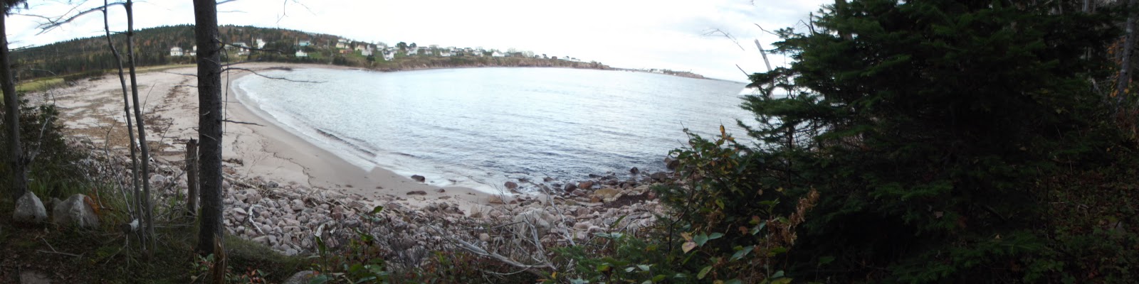
A short, but careful walk will reward you with some fantastic scenery by Presqu'île ("almost island"), a point that sticks into the Gulf just north of Cheticamp, or a few minutes after entering the Cape Breton Highlands National Park. Instead of coming along the path in the picture above, you might also walk along the rocky beach and then climb up to get to the greener peninsula.


This Inuksuk had fallen over, and I wasn't extraordinarily good at rebuilding it.


Sunday, 2 June 2013

L'Acadien


When new look-offs were added to the Acadien trail a few years ago, I decided to hike it again, but I wasn't expecting anything grandiose. I remembered doing it years ago and not being particularly wowed. Since I made that second trek, however, I've gone each and every summer. From 1200 ft above sea-level, there are now multiple panoramic views of the coast below and of the Cheticamp river. There are steep sections, and the return hike takes about three hours, more with breaks, but the views are stunning. If a local person suggests doing the Skyline Trail for the hundredth time, L'Acadien is my new proposed plan B--particularly since dogs are allowed and the trail is much quieter than the popular Skyline.

Map - Acadian
Map - Acadian Trail © Parks Canada  

Monday, 27 May 2013

Salt Mountain


Just a preview of the Bras d'Or lake on the way up.
A "Provincial Park" in our end of Nova Scotia can mean almost anything--often no more than a roadside picnic table with a garbage can. That's all one needs for outdoor shenanigans, really--though do please consider the pending arrival of the gatekeeper when you are engaged in anything lewd at twilight. That said, the Whycocomagh park stands out as an exception. On my last visit, the day-park or camping section was a bit too overgrown to land in a list of top destinations, but that can likely be attributed to PM Harper and the shortened park seasons forced by budget cutbacks. The hiking itself was a delight.

The Bras d'Or Look-off
The Whycocomagh park can be found just past the main town heading in the direction of Sydney. While there was only a short trail accessible there as of a few years ago, the insatiable hiker can now spend hours in the park, with just about ten kilometers of trails between the initial "Highlander" trail and up the more rugged "Scout" trail. The trailhead is across from the DNR Office, right after the campground entrance--close enough to Highway 105 to be a decent spot for tourists to stop.


Me, 'pretending' I can't handle the steepness?
The Highlander and Salt Mountain trail portions total about 3 and a half kilometers, so the initial section of trail is not long. It does climb 750 ft above the Bras d'Or Lake in no time, though, so it presents a little bit of a challenge. Continuing on with the Scout trail is trickier.  If you're lucky, as I was, you'll hear the shouts and cries of tubby little kids ahead of you to keep you going. Children, surprisingly, seem to have no difficulties with this one.


Whycocomagh means "Head of the Waters" in Mi'kmaq, referring to the area surrounding Salt Mountain. Across the bay from the Provincial Park lies the Mi'kmaq reserve.


Geocaches in area:
"Whycocomagh Provincial Park" N 45° 57.963 W 061° 06.606 Status: Good (6/3/13)
"Salt Mountain-Whycocomagh Village Lookoff" N 45° 57.954 W 061° 05.750 Status: Good (6/3/13)
"Salt Mountain-Bras d'Or Lake Lookoff" N 45° 57.840 W 061° 05.741 Status: Good (6/3/13)


Thursday, 16 May 2013

Coastal/Jack Pine

The Coastal and Jack Pine trails near Neil's Harbour are a definite treat whenever I can make it that far. There are two trail-heads for this one, one at Black Brook Cove, and the other nearer Neil's Harbour. I had begun on the Black Brook end some years ago, so decided to pursue the other, northern, end. After a bit of confusion, I managed to get my bearings. Check out this map.

I don't know what the rationale is behind this Parks Canada map, but putting north on the bottom just...stinks.
Here's a map from my car, complete with coffee stains.
Doing both the Coastal and Jack Pine trails includes about 13 kilometers, following the Atlantic Ocean from Neil's Harbour to Black Brook, elevating from sea level to over 100 ft. What I really enjoy about this trail is the mixed terrain, hiking amongst hardwoods, windy shoreline, crushed rock, etc. 


I caught sight of a number of gannets diving for fish, but took no clear pictures worth showing.


We were all alone out there, so Ella got to run free.


Half way through the Coastal Trail is the connection with Jigging Cove Brook trail. It's only 1.4 kilometers, so I decided to do it again, but was immediately reminded of why I told myself I should not have bothered with it the last time. It was very wet and boggy, as demonstrated here.


After a long day, I kind of wished I hadn't added an additional almost-three kilometers. In any case, when you start at the opposing end you have the opportunity to close with the Jack Pine loop, which is fairly short and easy and has only small gains in elevation.

Sunday, 12 May 2013

Le Vieux Chemin de Cap Rouge


This hike was newly developed in 2010 and follows the route of the "old" Cabot Trail from Trout Brook to a view up Jerome Mountain. There are foundations and building remains visible along the trail, and the top features a final look-off with views of the ocean and Presqu'île. The trail is 9 km return, climbing from 130 to 360 ft, so not particularly steep or challenging. It is also not a loop, so the distance can be cut in half if one wishes to park a car at either end, one near the Trout Brook picnic area and the other at the other end, which is accessible from the road.

 
Map - Le vieux chemin du Cap-Rouge
Map - Le vieux chemin du Cap-Rouge © Parks Canada
 As far as hikes in the National Park go, this one doesn't make my list of favorites. Still, it's an enjoyable stroll and it's nice to see Parks Canada continue to develop the park.

Sunday, 5 May 2013

Fishing Cove

Fishing Cove is another hike "down"--which is why a lot of hikers choose to take the long way in, and the short way out, which is all uphill. The longer route follows more water, which is something you might want to keep in mind for a pet. Parks Canada lists the longer route at 12 km return, and the shorter at 5.7 km. Both trail-heads can be found at the top of MacKenzie Mountain

Map - Fishing Cove
Map - Fishing Cove © Parks Canada

At the bottom, you'll be at a small ocean cove, and have the option of swimming in either fresh or salt water. This is also the site of the National Park's only "wilderness camping" site--something I've never really been interested in myself, because the park does not allow open fires on the site. If you were interested in camping here, it's pertinent to know that the walk back out is very steep, from sea level to 1,165 ft, and there are no garbage bins on site--everything must come back out with you. Registration must be made at either the Cheticamp or Ingonish centers. There is also no potable water on site. Those who do camp here seem to love it, and love the sunsets and sunrises of the ocean panorama, but there are other spots where I feel I can have the "wilderness" feeling and not sacrifice my campfire. 

When I do go to Fishing Cove, I definitely spend some time at the beach, or midway point of a return trip. It's often nice and cool by the water, and knowing what the trek back up has in store, I'll take my time. There are fishing opportunities here as well, though anglers should contact the Cheticamp or Ingonish offices of the park for permits and to confirm restrictions, since regulations in the park differ from the waters outside of the park.


Absolutely terrible, but this is the only picture I have in my stash of Fishing Cove at the moment.

Sunday, 7 April 2013

Gillis Falls

For those days when you might be a bit too tired for the exertion required by a bona-fide hike, there are many opportunities in Cape Breton for a quick stop at a look-off or waterfall. The CBRM's Gillis Falls are impressive for their pristine quality and relative closeness to our urban center. To get there, head towards Eskasoni First Nation from Sydney by taking exit 6W off Hwy 125 onto Hwy 4, and about 12 kilometers later right onto Hwy 216. Another right turn just over a kilometer later will take you onto Gillis Lake Road. From there, head north for about 3.5 km, and park on the side of the road just before the small bridge. The first waterfall, and a nice swimming hole, are on the lower side of the bridge. The approach is steep but short.


A trusted pair of insulated rubbers takes a person into the cold water without a problem.
The second falls are on the other side of the bridge, so you'll want to ascend back to the road. These are on private property, so you may want to drive up a little further to his driveway and ask the owner's permission before venturing forth. This driveway features a bridge--look down, and you'll see that you are now on top of the second falls. The owner wasn't home when we ventured over, so we decided to head down anyway, returning our car to its first parking spot and hopping the gate seen here on the upper side of the bridge. If you happened to be carrying your fishing gear and a Nova Scotia license, you would be allowed to access water via private property in any case.


An impressive flow of water right below the owner's driveway.
On our way back out, we met a man (not the owner), who said the landowner didn't mind people going to the falls as long as they weren't destructive, and that the "No Trespassing" signs were more or less intended to protect himself from people getting hurt on his property. It being early April, and with a fair amount of snow still on the ground, we didn't stick around for a picnic, though the falls' proximity to Sydney has me thinking that a favored takeout might be an enjoyable treat to bring next time.

Geocaches in area:
"Two Falls for the Price of One" N 46° 02.957 W 060° 23.56 Status: Good (4/6/13) GCJ7EY